


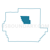
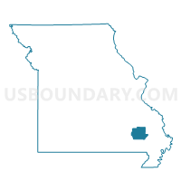
Silva Voting District, Wayne County, Missouri
About
Outline

Summary
| Unique Area Identifier | 611562 |
| Name | Silva Voting District |
| County | Wayne County |
| State | Missouri |
| Area (square miles) | 39.69 |
| Land Area (square miles) | 39.48 |
| Water Area (square miles) | 0.21 |
| % of Land Area | 99.47 |
| % of Water Area | 0.53 |
| Latitude of the Internal Point | 37.17012400 |
| Longtitude of the Internal Point | -90.45302500 |
Maps

Graphs
Select a template below for downloading or customizing gragh for Silva Voting District, Wayne County, Missouri


Neighbors
Neighoring Voting District (by Name) Neighboring Voting District on the Map
- Clubb Voting District, Wayne County, MO
- Coldwater Voting District, Wayne County, MO
- Greenville Voting District, Wayne County, MO
- Hiram Voting District, Wayne County, MO
- Lowndes Voting District, Wayne County, MO
- Patterson Voting District, Wayne County, MO
Top 10 Neighboring County Subdivision (by Population) Neighboring County Subdivision on the Map
- St. Francois township, Wayne County, MO (2,094)
- Logan township, Wayne County, MO (1,486)
- Cowan township, Wayne County, MO (627)
- Cedar Creek township, Wayne County, MO (448)